


tougnette - roc de fer - col jean Claude - les Allues

XavierFaidix
User
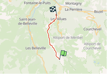

Length
13.4 km

Max alt
2403 m

Uphill gradient
221 m
Km-Effort
21 km

Min alt
1134 m

Downhill gradient
1479 m
Boucle
No
Creation date :
2023-07-09 08:06:26.915
Updated on :
2023-07-09 13:00:51.065
3h00
Difficulty : Easy

FREE GPS app for hiking
 SityTrail
IGN / Geographical institutes
SityTrail Plus
The world is yours!
About
Trail Walking of 13.4 km to be discovered at Auvergne-Rhône-Alpes, Savoy, Les Allues. This trail is proposed by XavierFaidix.
Positioning
Country:
France
Region :
Auvergne-Rhône-Alpes
Department/Province :
Savoy
Municipality :
Les Allues
Location:
Unknown
Start:(Dec)
Start:(UTM)
308788 ; 5026245 (32T) N.
Comments